

Its length is 120 km, from Ziamat Mansouriah in the West to Oued Z’Hour in the East. It has beaches and bays scattered here and there. It includes 54 beaches, 34 of which are open for swimming.
It has a corniche extending from Ziamat Al-Mansuriya to Al-Awana, interspersed with cork forests.
It is one of the most beautiful sites in the world, with amazing caves that were discovered in 1917 at the construction of the National Road No. 43. It is considered one of the wonders of nature in terms of shape and inscriptions made by stalagmites and stalactites, and it contains the El-Baz cave. It is a wide open cave on the road under the leadership of Mansouriya. It has been configured to receive all categories of visitors.
The rocky island: The most important characteristic of the western side of the coastal strip of Jijel is the presence of the rocky island of El Aouanna (06 ha), which is also called locally Dzira
Peninsula: There is a small peninsula in Bublatn (0,15 ha), and also the island of Borj Blida, which is called Andrew (04 ha).
Jijel occupies an area of 2 398 km², this area is dominated by a mountainous nature, accounting for 82%, while the plains and plateaus do not represent only 18%.
The most important of them are: Mount Tamzgida in Beni Yadjis, Mount Taounart in Aftis, Mount Bouazza in Djimla, Mount Sadat in Bordj T’har, Mount Guerrouche in the municipality of Selma Ben Ziada, Mount Al Maa El Bared in Texenna.
These mountains are covered with dense forest fabric that encourages mountain tourism and hunting. Their total area is estimated at about 136 787 ha, which represents 57% of the area of the province like: Bouafroun forest, El Ma El Bared forest, Bouhanche forest, Aydem forest, Beni Fergan forest, …
Located between El Aouanna and Ziama Mansouriah, 35 km west of Jijel, discovered in 1917 when the National Road N° 43 was opened.
It is one of the wonders of nature in terms of shape and carvings made by rows and vassals.
It contains strange forms embodied in nature across the world modelled on the Cremlin Palace in Russia, the Hero Tower of Pisa, the Statue of Liberty in America, the World Cup, A big tooth with its roots bearing the name “God” in Arabic, also a foetus in his mother’s abdomen, plus a three monkeys symbol of wisdom “Deaf, mute, blindness,” as well as wonderful musical sounds that give the atmosphere more excitement and pleasure.
Specialists explain how these phenomena was produced by calcification of rainwater, which is usually packed with mineral salts.
A prehistoric site, which is a wide open cave on the road in ziama Mansouriya. Opened in 2006 after its preparation and the completion of huge statues embodying the era of dinosaurs and the Stone Age man, what was called Homo sapiens, in addition to bats, as well as special lighting. It’s a great prehistoric painting
In this cave there is a large hall, 50 m wide, 60 m wide and 20 to 32 m high, on the southern side of the hall, there is an opening that has widened thanks to erosion, allowing one to enjoy the strange limestone rock forms.
The temperature in the cave is estimated at 16°, but it differs from the Wonderful caves in its lack of stalagmites and stalactites, to remain another tourist site in the Corniche capital.
Located on Mount Bouazza, municipality of Djimla. It’s a set of stalactites and stalagmites. It is the longest and most confusing cave of the wilaya because of its multiple accesses
The lighthouse of Ras El Afia, the vigilant guard of the Corniche, is located on the top of Ras El Afia, 500 m into the sea, starting from the beach with the same name and 06 km west of Jijel. It’s one of the 24 largest lighthouses on the Algerian coastline.
It was completed by the French sculptor Charles Salva in 1867 at the top of the “Griffat” using a type of local blue stone and was introduced in 1907 with mazout until 1936 when it was converted by electricity and then automated in 1992.
These are triangle-shaped tentacles that give a light signal in each cycle, and give a light signal every 5 seconds and can be observed by ships 45 km, 43 m above sea level and have coloured the outer plates and lighthouse dome in red.
The lighthouse is known for the legend of the rock of the rail that was destroyed by a ship that carried pilgrims from Bejaïa to Mecca. And the tales of “The Fireplace,” “The Tribal Seat,” and “Lala Eisha and Mary.”
In addition to all this, the lighthousewas visited by many monarchs and ministers in the 1950s, by Mali’s head of state, Saudi Arabia’s ambassador to the Zubara family, ambassadors to Danish countries, Sweden, France, and other artists and celebrities
Created in 2006 in Kissir, El Aouanna municipality, it extends over an area of 25 Ha, it houses several species of mammals as well as bird aviaries, it is a space of leisure and relaxation for citizens.
A station to attract tourists seeking recreation and comfort, the distinctive nature of PNT contributes to the development of mountain tourism.
Its total area covered 3 807 ha, characterized by its diverse vegetation and animal composition. It contains 137 species of aromatic plants and others of medical interest, 20 species of decorative plants, 17 species of trees and shrubs of environmental and economic importance, 135 species of fungi 15 mammals which 11 are protected by law, and 134 species of birds are distributed between jugs and waterfowl.
Created by wilaya decree N° 67/786 of 08/11/1997, located in a humid area on the coast of the municipality of Kheri Oued Adjoul, 32 km from the city of Jijel, which is located at 122 ha, is contained within the perimeter of the Benni Belaid tourist expansion area, selected in 1996 under the MEDWET project by the European Economic Community (EEC). This reserve is characterized by the embrace of birds and very rare plants.
- Lake Beni Belaid (El Ancer district): It occupies 120 ha and contains no less than 23 species of birds. It is known worldwide.
- Lake Ghadir Beni Hamza (El Kennar, Chekfa district): It occupies an area of about 36 ha and contains no less than 32 species of birds.
- Lake Ghadir Al-Marj (Taher): with its unique beauty, it occupies an area of 05 ha.
On the heights of the commune of Erraguene Souissi ,daira of Ziama Mansouriah, is between the wilayas of Sétif and Jijel, built in 1961, it is currently the pole of attraction of tourists and visitors including lovers of mountain tourism and water sports.
Located 62 Km from the chief town of the Wilaya and 05 Km from Selma Ben Ziada municipality, not far from the caves “the Madeleine”, 900 m from the national road.
This stream is located on the piedmont and flows at regular intervals: the phenomenon of runoff, the explanation of which has not been elucidated to date, lasts 10 mn, is interrupted for 40 mn and is repeated daily during the year. It is pure and clean water for consumption.
The result is that the site is frequented by many people in search of a peaceful place that can bring them strength and healing.
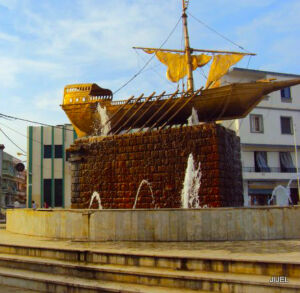 Adjacent to Kotama hotel and the crossing point of the main streets of Jijel city, there is Baba Aroudj boat, designed in a traditional 15th century style of copper and bronze, augmented by the beauty and rung of that fountain, which flashes its lights on the periodically flowing water towards the 12 oars of the ship.
This monument, whose images are in all websites, public bodies and associations and which symbolize the state of Jegel as well as other landmarks, was restored in the early 1990 as it drew Cornish visitors from all races and an area symbol.
The story of the Turkish leaders, Arroudj and Kheireddine, is known to all. They are Turkish brothers from the islands of the archipelago of Greece, Arroudj was born in 1437, and his brother a year later from a father named Yakoub Ben Yousef, who was making pottery on the said island. Historical sources report that the chiefs and elders of the Jegel tribes after the indiscopulence and the spanish of the spanish.
Some sources indicate that Baba Arrouj died in one of the first battles to open the capital to complete the march. His brother, Akheddin Barbros, took a great deal with the people of Jegel and gave them a lot of advantages, including paying royalty and taxes at a very small premium, and also giving them the opportunity to learn traditional crafts such as dessert making, feeding, dressing, shaving and others.
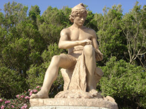
The Statue of the fisherman, is one of the historical symbols that bears witness to all the events in the city since its completion.
Constructed immediately after the 1856 earthquake that struck the Gigel area and destroyed everything there by the Italian sculptor “Guglialmi.”= = History = = In 1888, a plumbing factory is still named after one part of the statue in the absence of further writings of this remarkable work of art, located in the Republic Square, which surrounds it from the west, the ancient fishing port of the north, the great fountain of the city of Jigel to the south, and the municipal seat of Jigel to the east.
This art teacher symbolizes the intimate relationship of the bargain with the sea, their love of hunting and the craft it has been inherited by generations since ancient times, a landmark that reflects history and a testament to the Colonialist city.
This hunter’s sculpture, wearing a red cap symbolizing the liberty of an ancient people’s image, appears to be grabbing its nets, almost forgotten and ruined. In the wake of the celebration of national independence, he was shot in one of its parts. Fortunately, however, he was not subjected to total vandalism and continued to resist all factors of nature.